
- UTILITY MAPPING
- ASSET & INFRASTRUCTURE OPERATIONS
- DIGITAL TWIN
Building a single source of truth for Microsoft Campus infrastructure and property decisions

Microsoft’s Redmond campus spans hundreds of buildings, miles of underground fiber and copper infrastructure, and dozens of property easements and legal agreements. Managing it all requires more than static documents and disconnected records. It requires a living, unified spatial system that teams across the organization can rely on for day to day operations, legal review, and urgent field decisions.
Integral partnered with Microsoft’s Global Workplace Services team to design and build a suite of map-based applications on a shared geodatabase. What started as a proof of concept has grown into a platform that legal teams, facilities teams, operations staff, and infrastructure crews depend on daily, with two applications now in wide adoption and a third laying the foundation for a full campus digital twin.

3
integrated applications built on a shared campus geodatabase
1,000+
assets mapped
26
unique easement and agreement layers
-
Define the decision
Teams across Microsoft’s Redmond campus make consequential decisions every day that depend on accurate, accessible infrastructure and property data:
- Where is the underground fiber running beneath this construction site?
- Can I dig here?
- Which easements and agreements apply to this parcel?
- Who owns this vault?
- What are the property rights on this section of campus?
Before these applications existed, those questions were answered through ad hoc document searches across disconnected systems, static records, and manual processes. Legal teams lacked a unified view of easements and agreements. Infrastructure crews responding to 811 locate requests had no single authoritative source for fiber and vault data. Campus features existed across fragmented datasets with no shared spatial foundation.
The decisions to solve:
How can Microsoft centralize campus infrastructure, property rights, and spatial data into a unified, authoritative platform that reduces legal and operational risk, supports urgent field decisions, and lays the foundation for a full campus digital twin? -
Design the system
Integral partnered with Microsoft’s Global Workplace Services team to design a shared spatial infrastructure that could serve as the foundation for multiple applications across different teams and use cases. Rather than building three separate systems, the design centered on a single, shared geodatabase and shared data structures that all three applications could draw from.
The system design focused on:
- Establishing a single authoritative geodatabase for all campus infrastructure and property data
- Designing shared data structures that could support multiple applications and user types simultaneously
- Organizing data to serve both operational users responding to urgent field requests and legal teams conducting property reviews
- Building for long term governance, maintainability, and expansion to campuses beyond Redmond
- Laying the groundwork for a full campus digital twin starting with the Basemap as the spatial foundation
The result was a design architecture built not just for three applications but for the long term spatial intelligence needs of one of the world’s largest corporate campuses.
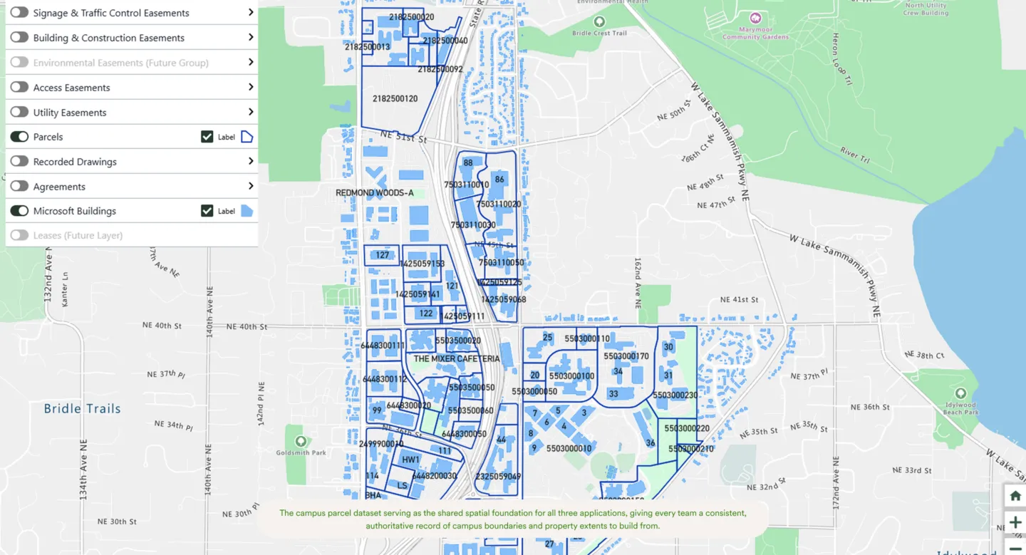
The campus parcel dataset serving as the shared spatial foundation for all three applications, giving every team a consistent, authoritative record of campus boundaries and property extents to build from. -
Build the platform
Integral designed and built three map-based applications on a shared ArcGIS Enterprise geodatabase, each purpose-built for a distinct set of users and operational needs while drawing from the same authoritative spatial foundation.
The Campus Infrastructure and Fiber Map gives operations teams and 811 locate responders a complete, up-to-date view of Microsoft’s underground fiber, copper, duct banks, and vaults on the Redmond campus. Custom front-end components on Azure Maps surface vault butterfly diagrams, audit reports, and cable inventory data. A lasso selection tool allows users to draw an area on the map and instantly surface all vaults and duct banks within it in a table view, supporting the mandated 48-hour 811 locate response window.
The Property Rights Map centralizes all easements, agreements, and recorded drawings tied to Microsoft’s campus parcels into one governed spatial environment. Legal teams, facilities staff, and external business groups can view access, utility, signage, traffic, building, and construction easements across 26 uniquely symbolized layers, with selectable parcels surfacing all associated agreements and documentation in a single side panel view.
The Campus Basemap aggregates 57 layers of campus features spanning transportation, landscaping, parking, accessibility, structures, and more into a single ArcGIS Experience Builder application. Designed as a campus-wide resource accessible to all Microsoft employees, it serves as the starting point for a full digital twin of the Redmond campus.
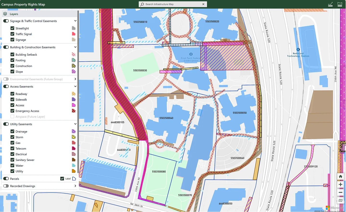
The Campus Property Rights Map surfacing all easements, agreements, and recorded drawings for a selected parcel in one side panel view, replacing ad hoc document searches across disconnected systems. -
Deliver the insight
Two of the three applications are now in wide adoption across Microsoft’s Redmond campus, depended on daily for operational and legal decisions that carry real consequences.
The Fiber Map has become the authoritative source of record for underground infrastructure data, giving operations teams and 811 locate responders the accurate, up-to-date information they need to meet mandated response windows and protect Microsoft from liability associated with utility strikes.
The Property Rights Map has eliminated ad hoc document searches across disconnected systems for legal teams, facilities staff, and external business groups. CELA and paralegal teams now have a single, governed environment for reviewing easements, agreements, and recorded drawings tied to specific parcels — reducing legal and operational risk across the campus.
The Campus Basemap, a developed proof of concept phase, has established the spatial foundation for what will become a full digital twin of the Redmond campus, with template data structures and methods that can be replicated across Microsoft campuses worldwide.
Together the three applications represent something larger than three tools. They are the beginning of a unified spatial operating system for one of the world’s most complex corporate campuses.
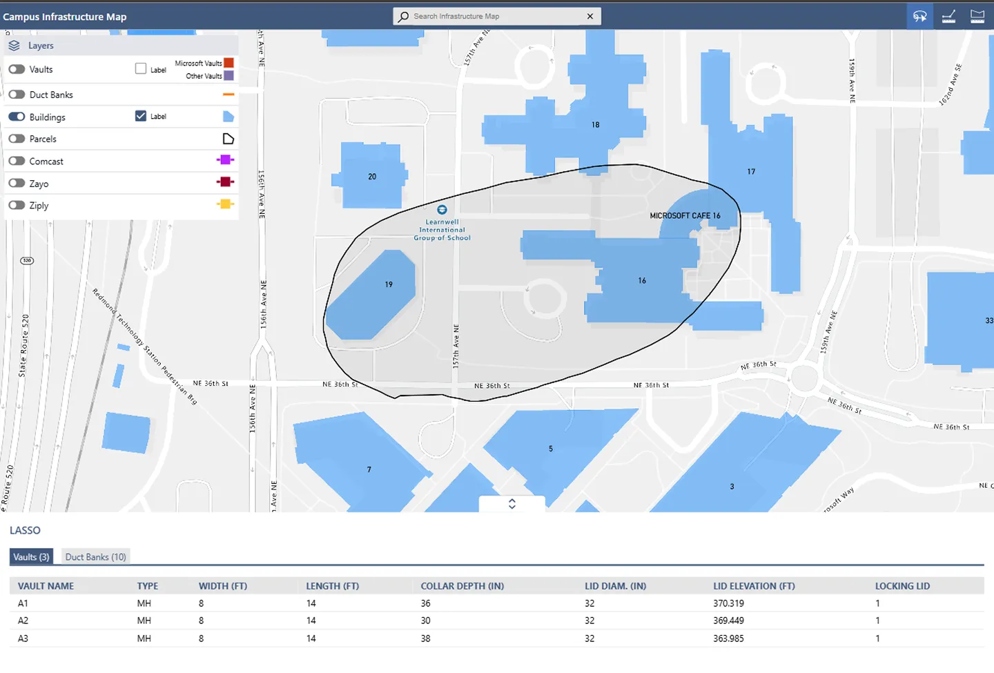
The lasso tool surfacing all vaults and duct banks within a selected area in a structured table view, giving 811 locate responders the precise infrastructure data they need to meet the mandated 48-hour response window (vault and duct data obfuscated). -
Support real-world use
The Microsoft Campus engagement has been an active, ongoing partnership since 2024. Microsoft’s Global Workplace Services team drives the roadmap, expressing priorities and interests that shape every iteration of the platform. The relationship is less vendor and client than it is a shared development team working toward a common goal.
The near term focus is threefold: maintaining the accuracy and governance of the underlying data, expanding adoption of the Fiber Map and Property Rights Map across more teams and use cases, and building out the Campus Basemap into a genuinely valuable, campus-wide resource for all Microsoft employees.
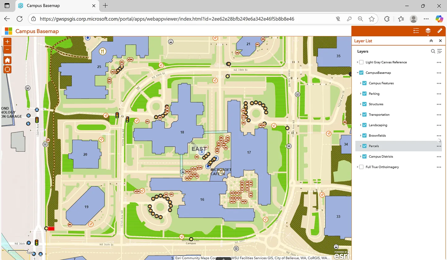
The Campus Basemap bringing 57 layers of campus features including structures, parking, transportation, landscaping, and brownfields into one accessible environment for all Microsoft employees and facilities teams. Together, we are building the spatial infrastructure for one of the world's most complex corporate campuses—redefining how it understands, manages, and evolves itself.
Complex problems deserve purpose-built solutions.
Understanding your challenge is step one. Tell us what you're working on and discover how we can work together to figure out the right solution.